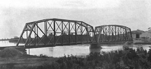
Round Island Channel Bridge – 1915
The Round Island Channel Bridge at milepost 27.9 – also known as Bridge 28A – crosses another major channel of the Copper River as the mainline crosses from the west to the east bank out of Cordova.
The bridge consists of (west to east) a 300 ft. and a 260ft. pin-connected Baltimore truss with arched upper chords. The steel spans were built by the American Bridge Company, shipped north, and erected by CR&NW construction crews.
A temporary trestle was constructed some 27 ft. downstream of the final structure to allow construction to proceed north while the final bridges were built. Work on this trestle started upon ice breakup on May 28, 1908, and was completed on July 4, 1908.
Final bridge construction commenced on July 1, 1908, with the arrival of C.M. McDonald, who served as general foreman. Work proceeded until river freezeup on Oct 17, 1908, and continued the following year on April 1. When the ice went out on May 28, 1909, work on the remaining piers and spans commenced, and the bridge was completed on August 10, 1909. Total estimated cost was $151,549.
On account of river ice being 4-8ft thick at this point, the piers were armored with old 56 ft. rails.
The steel bridges were converted to highway use in 1956-1957. It served as a link in the growing Copper River Highway until the Good Friday Earthquake of 1964. The quake completely demolished the Round Island Channel bridge. The center pier disintegrated completely, dropping the eastern-most (260ft.) truss into the river. The western 300ft. truss stayed attached to the island abutment, but the east end dropped into the water.
The entire structure was eventually demolished and replaced with modern bridges for the stub of the Copper River Highway that was rebuilt.
Note: The nearby Flag Point Bridge at milepost 27.1 is sometimes considered to include the Round Island Channel bridge in some accounts. For the purposes of this website, I consider it to be a separate and distinct structure.
Round Island Channel Bridge Photos


Sources
- “The Alaska Earthquake, March 27, 1964, Effects on Transportation and Utilities”. United States Department of the Interior, Reuben Kachadoorian, US Government Printing Office, 1968. GEOLOGICAL SURVEY PROFESSIONAL PAPER 545-C
- “Copper River Highway – Environmental Impact Statement” Alaska Department of Highways, Project S-0851, Southcentral District