I didn’t make as much progress over the Easter weekend as I’d hoped (so, pretty much par for the course), but I did get the end of track moved forward as far as the south Strelna control point. I also installed the first pieces of backdrop.
Strelna, A Very Brief History
Strelna, in reality, was a rather boring place. The real station had a water tank located south of the mainline and west of the low trestle over Strelna Creek. Near the tank base was a switch that lead to two spur tracks to the north-northwest, one ~530′ long, one 634′ long. Just a bit past the spur switches was the east siding switch, a ~1350′ siding, and the west siding switch. The station was a small – single level, probably two rooms given the freight door on the west end – and appears to have been situated between the siding and main near the east siding switch. There was also what appears to be a motorcar shed to the south of the tracks, across from the station.
Strelna was often mentioned in the early days as the potential start of a branch line to the copper prospects to the north of town. The major player was always the Hubbard-Elliott copper prospects, located about 16 miles north of Strelna and over the ridge on Elliott Creek. The Elliott Creek basin apparently did produce somewhat, with the ore begin hauled down to the railhead at Strelna, but I have so far been unable to find any production numbers. Various sources mention both a surveying a 17.5 mile branch line and a 17-mile tramway linking the mines to the CR&NW’s mainline. The branch would come in just west of Strelna, at a location sometimes designated “Elliott Junction”.
The Hubbard-Elliott claims never seem to have amounted to much despite their oft-touted prospects. The concern was still reported in limited operation in the early 1920s, but beyond that there is little record. I suspect either the claims were exaggerated, or the brutal weather, poor financial backing, and lack of transportation access doomed them.
There was also exploration and development work done on Nugget Creek, about an equal distance east-northeast of Strelna, near the headwaters of the Kuskulana. Nugget Creek interested prospectors – and got its name – from a two ton native copper nugget found in the streambed. However, exploration never produced much – a few hundred tons of ore at the most – and Nugget Creek was abandoned by 1916.
Strelna on the Layout
Strelna – the model version – got a bit of a redesign over the past week from what I originally drew in the plans. I wanted to reflect the possibility that the copper deposits were proven viable, probably by SX-EW extraction rather than traditional milling and concentration, but I didn’t want to model another fictional branch or have Strelna turned into more of a town. Basically, I wanted it to remain as a decent size passing siding and a handful of industry tracks for inbound materials and outbound mine products, but little else. Strelna just isn’t far enough from Chitina to justify any duplication. Anything Chitina would provide – such as fuel oil, LPG, etc. – would just get trucked to Strelna. Duplication of facilities wouldn’t make any sense.
The model version isn’t as unfaithful as it might seem at first. I started with the prototype – a siding approximately 1350 feet in length, or roughly 8.5 feet in N scale, located on the north side of the mainline. (North, in this case, is towards the aisle.) The 8 ft siding fits perfectly with about the maximum size of ore trains I want to operate. The siding, like all major sidings on my present-day CRNW, will be controlled via CTC. I plan to place a set of culverts just past the north siding switch to cross Strelna Creek, and put concrete tank footers up close to the culverts to mark where the tank used to live.
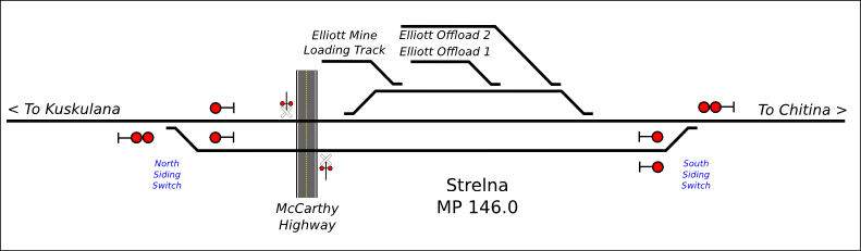
The prototype of Strelna had two short spurs north/east of what I’m referring to as the “north siding switch”. These were likely used as tracks to set out supplies for the mining concerns to the north and northeast, as well as for the hotel at Strelna (which burned in the late 1920s). I’ve decided to move them halfway down the siding and expand them to support a theoretical producing mine based around the idea of the Hubbard-Elliott properties being developed, though on a much later timeline than Kennecott.
Given that I don’t want to model another entire mine complex, I’m going with the idea that the “new Hubbard-Elliott mine” is mostly solvent extraction, and therefore doesn’t load out concentrate or raw ore. It only loads out copper cathodes, which will be transferred – truck to boxcar – at a facility on the “loading track” spur. As far as inbound loads, most will be extraction chemicals (primarily sulfuric for running the SX-EW leaching process), blasting agents, and fuel. The occasional load of heavy equipment or construction supplies would be completely reasonable as well. These will go into the two offload tracks, where they’ll be transferred to trucks for the return journey to the mine.
The pictures aren’t the most current – I took these two weekends ago. Since then I’ve finished the Strelna spurs and started wiring the whole mess, which involved putting a double-wide electrical panel under the south siding switch area.


I to am building an N scale model of mile 189 to 196 of the CR&NW RR. It is about 40 feet of track and 18 switches. Intended to be operable by kids and adults visiting the McCarthy-Kennicott Museum in McCarthy. We may have a good deal of information you could use.
I look forward to future correspondence.
Bob Cook
Bob –
Sorry, I’d been meaning to get back to you, but putting it off until I had my itinerary to CRNW country pinned down. Looks like I’ll be out to McCarthy at the very end of August/early September. I’d always appreciate the opportunity to meet a fellow CRNW modeler, and I’m very much looking forward to visiting with the staff at the museum and learning just how much I don’t yet know about the history of the area and the railroad. Feel free to drop me an email backchannel at ndholmes@drgw.net if you want.
How’s the layout for the museum coming along?
I stumbled upon this blog and am very curious about what you are doing. As curator at the museum here in Cordova, it occurs to me that you must have some detailed information about the CR&NW RY that we here at the museum might not have, regarding details of history, photographs, etc. Would you be willing to share any photos or information with the museum? Also, who are you and where are you?
Thanks. I look forward to checking on your progress with this.
Denis
Denis – Sorry for the delay in responding. When you posted that, I was actually out in Kennecott/McCarthy for a few days. Now that I’m down in Anchorage, I’m catching up on things.
Let’s start with the easy question – I’m Nathan Holmes, just your average rail history enthusiast and model railroader from Colorado who happens to have an interest in the Copper River. When I started the new layout about three years ago, I decided to act on a long-brewing idea to create an N scale modern day version of the Copper River & Northwestern.
Unfortunately, I don’t have any long-lost file box of detailed CRNW records. I’m working purely from published photos, things I’ve found roaming around on the internet, historical accounts and modern archaeological surveys, etc., along with some amount of tromping around with a tape measure. (My personal collections of photos/documents/artifacts are primarily related to the D&RGW, although I’ve picked up a few CRNW related items over the years.)
The length of the Strelna siding is derived from the track survey documents and the location of the station/warehouse building was derived from a photo, both of which were scanned and posted over the years by Ron Simpson. Upon digging around in the Anchorage library yesterday, Buzzell and McMahan came up with a completely different track arrangement in their 1995 “McCarthy Road Cultural Resources Reconnaissance Survey”, but their arrangement diagram disagrees with photographic evidence and even their own description. I’m currently doing some head scratching trying to figure out which, if either, is correct.
Actually contacting the Cordova Historical Society has been on my list for some time, but I’ve been putting it off. I haven’t made much progress with the BLM or National Archives on figuring out where the original line survey documents went. Dr. Buzzell references them in a number of his cultural survey reports, and notes that the CHS may have copies. I’d hoped to make it down to Cordova on this trip north, but timing just didn’t work.
Anything I have in terms of documents and photos I’m willing to share with anyone interested. My guess is that over time most of it will wind up here anyway. I’m also thinking about starting a discussion email list for those interested in the CR&NW, just to provide a forum to discuss historical and technical details of the line and hopefully solve some of these puzzles.